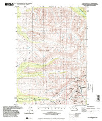
1994 Map of Anchorage D-7
USGS Topo · Published 2002About this map
Mining operations and remote alpine passes define this section of the Talkeetna Mountains north of Willow. Based on topography from 1949 with updated 1994 planimetry, the map reveals a landscape heavily influenced by the search for gold and minerals. The southeastern corner is particularly dense with historic workings, including the Lucky Shot Mine, Gold Bullion Mine, and the Independence Mine. These sites are linked by the Willow Fishhook Road as it climbs toward Hatcher Pass and Skyscraper Peak.
Find a feature on this map
49 named features on this map. Tap any name to fly to it.
Don’t see what you’re looking for? This feature index may not catch every label — zoom into the map to look around manually.
Map Details
Editions of this 1994 Anchorage D-7 Map
This is the sole edition of this map. No revisions or reprints were ever made.
Other maps of this area

1949 · Anchorage D-7
USGS Topo · 1:63,360

1949 · Anchorage D-8
USGS Topo · 1:63,360

1950 · Talkeetna Mountains
USGS Topo · 1:250,000

1950 · Anchorage C-8
USGS Topo · 1:63,360

1950 · Anchorage D-6
USGS Topo · 1:63,360

1950 · Anchorage C-7
USGS Topo · 1:63,360

1950 · Talkeetna Mountains A-6
USGS Topo · 1:63,360

1950 · Talkeetna Mountains A-5
USGS Topo · 1:63,360

1951 · Anchorage
USGS Topo · 1:250,000

1951 · Anchorage C-6
USGS Topo · 1:63,360