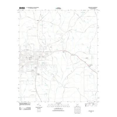
2011 Map of Andalusia
USGS Topo · Published 2011About this map
Andalusia serves as the primary hub in this early 21st-century portrait of southern Alabama, where a dense network of municipal streets gives way to the creek-fed lowlands of Covington County. The landscape is defined by its significant memorial sites, including the centrally located Magnolia Cemetery and Southside Cemetery, as well as the more peripheral Covington Memorial Gardens. Hydrological features like Five Runs Creek and Turkey Creek branch through the terrain, while the Andalusia-Opp Airport and the village of Sanford anchor the eastern reaches. The map reveals a transition from the urban structure around the Andalusia Post Office to the recreational and rural outskirts, notably the Old Pine Golf Course and the various branches of Mill Creek. This record documents the region's modern infrastructure, including the reach of County Hwy 49 and the residential expansion toward Pineview Lake.
Find a feature on this map
87 named features on this map. Tap any name to fly to it.
Don’t see what you’re looking for? This feature index may not catch every label — zoom into the map to look around manually.
Map Details
Editions of this 2011 Andalusia Map
This is the sole edition of this map. No revisions or reprints were ever made.
Other maps of this area

1953 · Andalusia
USGS Topo · 1:250,000

1957 · Andalusia
USGS Topo · 1:250,000

1971 · Carolina
USGS Topo · 1:24,000

1971 · Libertyville
USGS Topo · 1:24,000

1971 · Dozier
USGS Topo · 1:24,000

1971 · Onycha
USGS Topo · 1:24,000

1971 · River Falls
USGS Topo · 1:24,000

1971 · Andalusia
USGS Topo · 1:24,000

1971 · Gantt
USGS Topo · 1:24,000

1971 · Red Level
USGS Topo · 1:24,000