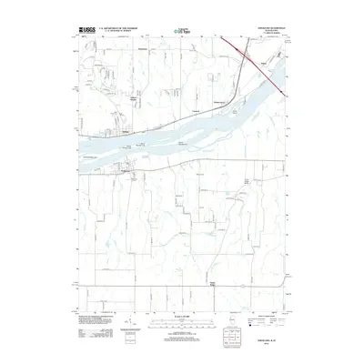
2012 Map of Andalusia
USGS Topo · Published 2012About this map
The Mississippi River creates a natural divide through this quadrangle, with the river towns of Buffalo and Andalusia facing each other across a complex network of islands and side channels. The northern bank in Scott County, Iowa, features a series of established settlements including Jamestown, Linwood, and Walnut Grove, while the southern Illinois side transitions from the river bottoms to the Army Ridge Bluffs. This landscape reflects a long history of river-based commerce and upland agricultural settlement, marked by numerous small burial grounds like Asbury Cem and Saint Peter's Cem. The hydrology is defined by the Andalusia Slough and several numbered landmasses, including Island Number 317 and Horse Island. Inland, the terrain is carved by Fancy Cr and Turkey Hollow Cr, which feeds into the Turkey Hollow Reservoir near the village of Taylor Ridge.
Find a feature on this map
61 named features on this map. Tap any name to fly to it.
Don’t see what you’re looking for? This feature index may not catch every label — zoom into the map to look around manually.
Map Details
Editions of this 2012 Andalusia Map
This is the sole edition of this map. No revisions or reprints were ever made.
Other maps of this area

1890 · Durant
USGS Topo · 1:62,500

1891 · Davenport
USGS Topo · 1:62,500

1894 · Durant
USGS Topo · 1:62,500

1894 · Davenport
USGS Topo · 1:62,500

1901 · Rock Island
USGS Topo · 1:125,000

1910 · Rock Island
USGS Topo · 1:125,000

1912 · Milan
USGS Topo · 1:62,500

1916 · Edgington
USGS Topo · 1:62,500

1938 · Edgington
USGS Topo · 1:62,500

1944 · Milan
USGS Topo · 1:62,500