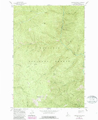
1966 Map of Anderson Butte
USGS Topo · Published 1987About this map
Nez Perce National Forest dominates this topographic survey, revealing a landscape of steep timbered ridges and a intricate network of drainages. The topography is anchored by Anderson Butte in the south, featuring the Anderson Butte Lookout Tower, a critical vantage point for forest management. The map details a complex system of pack trails, such as Pack Trail 579, which follow the high ground along Horse Ridge and Sheep Drive Ridge. These trails provide the primary access through the drainage basins of Meadow Creek and the East Fork American River. A solitary Grave located near Sheep Drive Ridge offers a poignant trace of the area's human history, likely connected to early forest service activity or high-country sheep herding. The drainage patterns of Horse Creek and Fivemile Creek illustrate the formidable terrain that defined backcountry life in the mid-1960s.
Find a feature on this map
31 named features on this map. Tap any name to fly to it.
Don’t see what you’re looking for? This feature index may not catch every label — zoom into the map to look around manually.
Map Details
Editions of this 1966 Anderson Butte Map
2 editions found

Other maps of this area

1911 · Lolo
USGS Topo · 1:250,000

1913 · Lolo
USGS Topo · 1:250,000

1956 · Elk City
USGS Topo · 1:250,000

1956 · Hamilton
USGS Topo · 1:250,000

1959 · Hamilton
USGS Topo · 1:250,000

1960 · Elk City
USGS Topo · 1:250,000

1960 · Hamilton
USGS Topo · 1:250,000

1964 · Hamilton
USGS Topo · 1:250,000

1966 · Selway Falls
USGS Topo · 1:24,000

1966 · Elk City
USGS Topo · 1:24,000