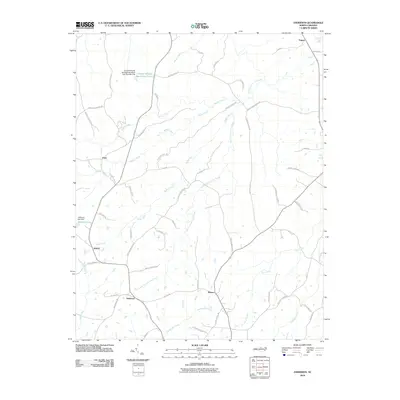
2010 Map of Anderson
USGS Topo · Published 2010About this map
Anderson and the surrounding Caswell County countryside are defined by a network of rural routes and winding waterways in the early twenty-first century. The landscape is dominated by the watershed of Byrds Creek and South Country Line Creek, which feed into larger systems like Hyco Creek to the southeast. Small community hubs such as Fitch, Jericho, and Baynes anchor the road system, which is populated with family-named thoroughfares including Marshall Graves Rd and Rudd Ridge Rd. Local industry and resource management are visible through features like Williams Lake Dam and the Caswell Wildlife Mgmt Area Pond O. The presence of Byrds Sawmill Rd suggests the enduring legacy of local timber processing, while the convergence of roads at Anderson highlights its role as a central point for this agricultural and timber-rich region.
Find a feature on this map
57 named features on this map. Tap any name to fly to it.
Don’t see what you’re looking for? This feature index may not catch every label — zoom into the map to look around manually.
Map Details
Editions of this 2010 Anderson Map
This is the sole edition of this map. No revisions or reprints were ever made.
Other maps of this area

1953 · Greensboro
USGS Topo · 1:250,000

1954 · Greensboro
USGS Topo · 1:250,000

1962 · Greensboro
USGS Topo · 1:250,000

1966 · Greensboro
USGS Topo · 1:250,000

1967 · Cedar Grove
USGS Topo · 1:24,000

1968 · Leasburg
USGS Topo · 1:24,000

1968 · Ridgeville
USGS Topo · 1:24,000

1969 · Lake Burlington
USGS Topo · 1:24,000

1969 · Burlington NE
USGS Topo · 1:24,000
1972 · Anderson
USGS Topo · 1:24,000