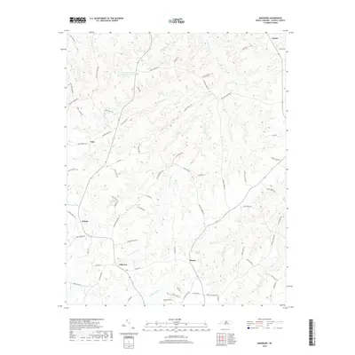
2019 Map of Anderson
USGS Topo · Published 2019About this map
The Caswell Wildlife Mgmt Area dominates the northern reaches of this Caswell County landscape, providing a preserved habitat amidst the rural agricultural lands. Small settlements and historic crossroads including Anderson, Fitch, Baynes, and Jericho anchor the social geography of the area. The terrain is deeply defined by a network of waterways, most notably the meandering paths of S Country Line Cr, Hyco Cr, and Penson Cr, which have historically dictated the placement of roads and farms. A sophisticated network of family-named roads, such as Marshall Graves Rd and George Russell Rd, hints at the long-standing genealogical roots of the local community. The presence of Caswell Wildlife Mgmt Area Pond O and Williams Lake further illustrates the significance of water management in this Piedmont environment.
Find a feature on this map
73 named features on this map. Tap any name to fly to it.
Don’t see what you’re looking for? This feature index may not catch every label — zoom into the map to look around manually.
Map Details
Editions of this 2019 Anderson Map
This is the sole edition of this map. No revisions or reprints were ever made.
Other maps of this area

1953 · Greensboro
USGS Topo · 1:250,000

1954 · Greensboro
USGS Topo · 1:250,000

1962 · Greensboro
USGS Topo · 1:250,000

1966 · Greensboro
USGS Topo · 1:250,000

1967 · Cedar Grove
USGS Topo · 1:24,000

1968 · Leasburg
USGS Topo · 1:24,000

1968 · Ridgeville
USGS Topo · 1:24,000

1969 · Lake Burlington
USGS Topo · 1:24,000

1969 · Burlington NE
USGS Topo · 1:24,000
1972 · Anderson
USGS Topo · 1:24,000