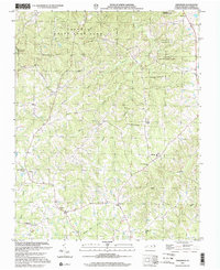
2002 Map of Anderson
USGS Topo · Published 2002About this map
Caswell State Game Land dominates the northern reaches of this rural Piedmont landscape, where the terrain is defined by the branching tributaries of the Country Line Creek and Hyco Creek watersheds. Small crossroads communities and agricultural hubs like Anderson, Baynes, and Topnot are connected by a network of local roads that thread between numerous rural congregations. The map detail reflects a deeply rooted community structure, evidenced by the high density of local landmarks including Sweet Gum Grove Ch, Bush Arbor Ch, and Allred Memorial Tabernacle. For genealogists and local historians, the presence of the Sweet Gum Sch and the Cherokee Scout Reservation provides specific points of interest for tracing 20th-century social and educational history in this corner of Caswell County.
Find a feature on this map
30 named features on this map. Tap any name to fly to it.
Don’t see what you’re looking for? This feature index may not catch every label — zoom into the map to look around manually.
Map Details
Editions of this 2002 Anderson Map
This is the sole edition of this map. No revisions or reprints were ever made.
Other maps of this area

1953 · Greensboro
USGS Topo · 1:250,000

1954 · Greensboro
USGS Topo · 1:250,000

1962 · Greensboro
USGS Topo · 1:250,000

1966 · Greensboro
USGS Topo · 1:250,000

1967 · Cedar Grove
USGS Topo · 1:24,000

1968 · Leasburg
USGS Topo · 1:24,000

1968 · Ridgeville
USGS Topo · 1:24,000

1969 · Lake Burlington
USGS Topo · 1:24,000

1969 · Burlington NE
USGS Topo · 1:24,000
1972 · Anderson
USGS Topo · 1:24,000