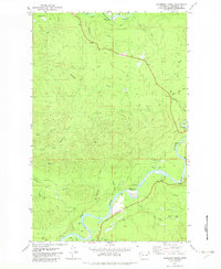
1982 Map of Anderson Creek
USGS Topo · Published 1982About this map
The Bogachiel River and Hoh River anchor this 1980s landscape in Jefferson County, where the dense drainage networks of the Olympic Peninsula are meticulously documented. The map reveals a land defined by its waterways and timber-related infrastructure, including several Gravel Pits and the winding Upper Hoh Road. A unique historical marker is the Lacy Oil Seep (Site), located west of Anderson Creek, pointing to early mineral exploration in the region. Recreation is concentrated along the riverbanks, evidenced by the Cottonwood Campground and an adjacent Picnic Area. From the heights of Lagitos Hill in the northwest to the numerous tributaries like Hell Roaring Creek and Mosquito Creek, the map traces the intricate topography of a managed forest landscape just before the turn of the millennium.
Find a feature on this map
24 named features on this map. Tap any name to fly to it.
Don’t see what you’re looking for? This feature index may not catch every label — zoom into the map to look around manually.
Map Details
Editions of this 1982 Anderson Creek Map
This is the sole edition of this map. No revisions or reprints were ever made.
Other maps of this area

1939 · Forks
USGS Topo · 1:62,500

1943 · Spruce Mountain
USGS Topo · 1:62,500

1943 · Copalis Beach
USGS Topo · 1:250,000

1951 · Copalis Beach
USGS Topo · 1:250,000

1956 · Destruction Island
USGS Topo · 1:62,500

1956 · Spruce Mtn.
USGS Topo · 1:62,500

1956 · Salmon River
USGS Topo · 1:62,500

1957 · Forks
USGS Topo · 1:62,500

1957 · Copalis Beach
USGS Topo · 1:250,000

1963 · Copalis Beach
USGS Topo · 1:250,000