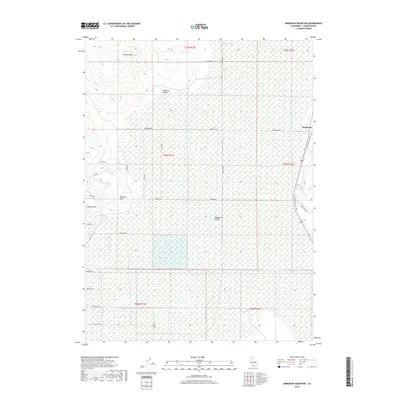
2018 Map of Anderson Mountain
USGS Topo · Published 2018About this map
Madeline Plains dominate the landscape of this Lassen County interior, revealing a high-desert terrain defined more by its vast, open flats and dry lakebed characteristics than by dense settlement. The small community of Brockman sits on the eastern edge of the sheet, serving as a primary point of reference along the LLT/T Modoc Line Rail Trail, which traces the historical path of the Nevada-California-Oregon Railway. To the northwest, the topography shifts abruptly at Anderson Mtn and the carved terrain of Anderson Canyon, creating a sharp contrast between the upland peaks and the basin floor. The grid of rural roads, including Brockman Rd and Williams Rd, outlines a pattern of land division typical of the eastern Sierra plateau, while features like Ninemile Point mark the transition between the plains and the surrounding highlands.
Find a feature on this map
31 named features on this map. Tap any name to fly to it.
Don’t see what you’re looking for? This feature index may not catch every label — zoom into the map to look around manually.
Map Details
Editions of this 2018 Anderson Mountain Map
This is the sole edition of this map. No revisions or reprints were ever made.
Other maps of this area

1886 · Alturas
USGS Topo · 1:250,000

1886 · Honey Lake
USGS Topo · 1:250,000

1891 · Honey Lake
USGS Topo · 1:250,000

1892 · Alturas
USGS Topo · 1:250,000

1893 · Honey Lake
USGS Topo · 1:250,000

1954 · Grasshopper Valley
USGS Topo · 1:62,500

1954 · Ravendale
USGS Topo · 1:62,500

1954 · Alturas
USGS Topo · 1:250,000

1955 · Westwood
USGS Topo · 1:250,000

1958 · Alturas
USGS Topo · 1:250,000