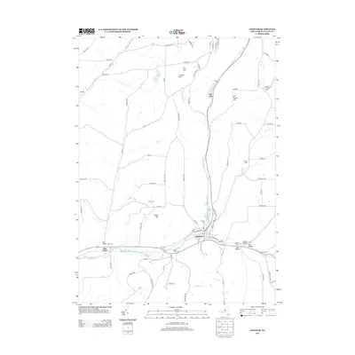
2013 Map of Andover
USGS Topo · Published 2013About this map
Andover serves as the central hub of this Allegany County landscape, where the waters of Dyke Cr and Railroad Brook meet. The settlement pattern is defined by a series of narrow valleys and prominent heights, such as Pingry Hill and Jericho Hill, which channel the local road network. Genealogists will find a high density of burial sites concentrated near the village and along the creek beds, including Hillside Cem, Saint Johns Cem, and Gate of Heaven Cem. To the west, the smaller community of Elm Valley sits near Dyke Cem, illustrating the early 21st-century rural character of the region. The map also documents agricultural landmarks like Sunny Cove Farm and Kent Farms, alongside several distinct geographic hollows such as Shovel Hollow and Quig Hollow that mark the southern terrain.
Find a feature on this map
92 named features on this map. Tap any name to fly to it.
Don’t see what you’re looking for? This feature index may not catch every label — zoom into the map to look around manually.
Map Details
Editions of this 2013 Andover Map
This is the sole edition of this map. No revisions or reprints were ever made.
Other maps of this area

1915 · Hornell
USGS Topo · 1:62,500

1916 · Canaseraga
USGS Topo · 1:62,500

1918 · Hornell
USGS Topo · 1:62,500

1926 · Wellsville
USGS Topo · 1:62,500

1926 · Greenwood
USGS Topo · 1:62,500

1940 · Canaseraga
USGS Topo · 1:62,500

1950 · Elmira
USGS Topo · 1:250,000

1958 · Elmira
USGS Topo · 1:250,000

1962 · Elmira
USGS Topo · 1:250,000
1964 · Alfred
USGS Topo · 1:24,000