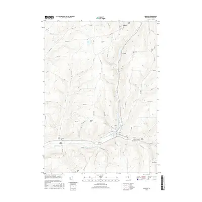
2016 Map of Andover
USGS Topo · Published 2016About this map
Andover and the neighboring hills of Allegany County are meticulously documented in this 2016 survey, revealing a landscape defined by its deep valleys and prominent peaks. The village of Andover sits at the confluence of Railroad Brook and Dyke Creek, surrounded by steep terrain such as Jericho Hill and Pingry Hill. For genealogists, the map provides precise locations for numerous burial grounds, including Hillside Cem, Valley Brook Cem, and the Gate of Heaven Cem. Moving north toward Alfred, the topography shifts along the high ridges of Tip Top and Ben Socker Hill. The settlement at Elm Valley remains a distinct point of interest to the west, situated near the headwaters where Vandermark Cr begins its descent. This modern topographic study serves as a definitive record of the established rural road network and the enduring landmarks of the southern Tier.
Find a feature on this map
78 named features on this map. Tap any name to fly to it.
Don’t see what you’re looking for? This feature index may not catch every label — zoom into the map to look around manually.
Map Details
Editions of this 2016 Andover Map
This is the sole edition of this map. No revisions or reprints were ever made.
Other maps of this area

1915 · Hornell
USGS Topo · 1:62,500

1916 · Canaseraga
USGS Topo · 1:62,500

1918 · Hornell
USGS Topo · 1:62,500

1926 · Wellsville
USGS Topo · 1:62,500

1926 · Greenwood
USGS Topo · 1:62,500

1940 · Canaseraga
USGS Topo · 1:62,500

1950 · Elmira
USGS Topo · 1:250,000

1958 · Elmira
USGS Topo · 1:250,000

1962 · Elmira
USGS Topo · 1:250,000
1964 · Alfred
USGS Topo · 1:24,000