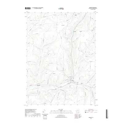
2019 Map of Andover
USGS Topo · Published 2019About this map
The village of Andover serves as the central hub of this Allegany County landscape, situated at the confluence of several vital waterways including Dyke Cr and Railroad Brook. The settlement pattern follows the narrow valley floors, with concentrated residential blocks in Andover and the smaller hamlet of Elm Valley to the west. This geography is defined by prominent high points such as Jericho Hill and Tip Top, which rise above the surrounding creek beds and hollows. For those tracing local heritage, the map identifies numerous small burial grounds, including the Cole Dyke Cem and Valley Brook Cem. The presence of Andover Pond and Foster Lake highlights the importance of water resources in the upland terrain. The rural character of the area is further evidenced by a dense network of country roads, many named after local families such as Bullard Rd and Lynch-Casey Rd, connecting isolated farms to the river valleys.
Find a feature on this map
78 named features on this map. Tap any name to fly to it.
Don’t see what you’re looking for? This feature index may not catch every label — zoom into the map to look around manually.
Map Details
Editions of this 2019 Andover Map
This is the sole edition of this map. No revisions or reprints were ever made.
Other maps of this area

1915 · Hornell
USGS Topo · 1:62,500

1916 · Canaseraga
USGS Topo · 1:62,500

1918 · Hornell
USGS Topo · 1:62,500

1926 · Wellsville
USGS Topo · 1:62,500

1926 · Greenwood
USGS Topo · 1:62,500

1940 · Canaseraga
USGS Topo · 1:62,500

1950 · Elmira
USGS Topo · 1:250,000

1958 · Elmira
USGS Topo · 1:250,000

1962 · Elmira
USGS Topo · 1:250,000
1964 · Alfred
USGS Topo · 1:24,000