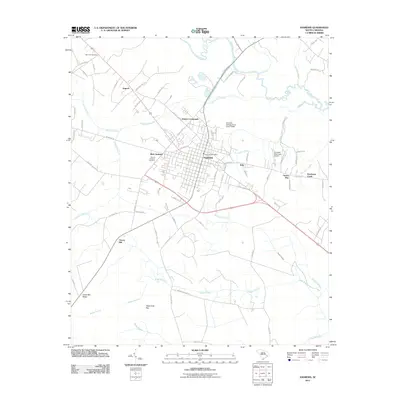
2011 Map of Andrews
USGS Topo · Published 2011About this map
Andrews serves as a central hub of activity along the Seaboard Coast Line railroad in this 2011 survey of Georgetown County. The settlement pattern radiates from the town center to include West Andrews, Harper Crossroads, and the rural community of Antioch. The landscape is defined by its complex hydrology, with the Black River carving through the northern territory and a series of swamps and bays—including Boggy Swamp, Waterhole Bay, and Big Dam Swamp—dominating the low-lying terrain to the south. Local heritage is preserved at sites like Mount Lebanon Cemetery and Harmony Cemetery, while modern infrastructure is represented by the Andrews Municipal Airport and the Andrews Post Office. To the east, the distinct wetland characteristics of Green Bay and Puncheon Creek highlight the coastal plain's transition into dense swampy basins like Bond Swamp.
Find a feature on this map
80 named features on this map. Tap any name to fly to it.
Don’t see what you’re looking for? This feature index may not catch every label — zoom into the map to look around manually.
Map Details
Editions of this 2011 Andrews Map
This is the sole edition of this map. No revisions or reprints were ever made.
Other maps of this area

1942 · Cedar Creek
USGS Topo · 1:24,000

1943 · Olin
USGS Topo · 1:31,680

1943 · Trio
USGS Topo · 1:24,000

1943 · Kilsock Bay
USGS Topo · 1:24,000

1943 · Rhems
USGS Topo · 1:24,000

1943 · Andrews
USGS Topo · 1:24,000

1943 · Jamestown
USGS Topo · 1:24,000

1946 · Indiantown
USGS Topo · 1:62,500

1949 · Georgetown
USGS Topo · 1:250,000

1967 · Georgetown
USGS Topo · 1:250,000