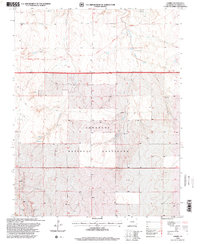
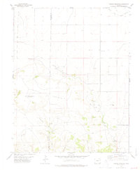
1996 Map of Andrix
USGS Topo · Published 2000About this map
The Comanche National Grassland dominates this portion of southeastern Colorado, where the wide, open plains are incised by the drainage of Mustang Creek and Lou Creek. This landscape preserves a critical piece of American frontier history, marked by the clearly delineated Historic Santa Fe Route (Granada Fort Union) cutting across the northern sections. This wagon road represents one of the primary arteries of 19th-century trade and military movement between the Arkansas River and New Mexico. The small settlement of Andrix serves as a lonely geographic anchor in the southern half of the map, accompanied by a small Cem that provides a tangible link for genealogists and local historians tracing the families who homesteaded this dry, shortgrass prairie during the mid-to-late 20th century.
Find a feature on this map
9 named features on this map. Tap any name to fly to it.
Don’t see what you’re looking for? This feature index may not catch every label — zoom into the map to look around manually.
Map Details
Editions of this 1996 Andrix Map
This is the sole edition of this map. No revisions or reprints were ever made.
Other maps of this area

1892 · Mt Carrizo
USGS Topo · 1:125,000

1955 · La Junta
USGS Topo · 1:250,000

1958 · La Junta
USGS Topo · 1:250,000

1968 · La Junta
USGS Topo · 1:250,000

1978 · Pintada Creek
USGS Topo · 1:24,000

1978 · Utleyville
USGS Topo · 1:24,000
1978 · Robbers Roost Canyon
USGS Topo · 1:24,000
1978 · Table Mesa
USGS Topo · 1:24,000
1978 · Buck Canyon
USGS Topo · 1:24,000
1978 · Carrizo Mountain
USGS Topo · 1:24,000