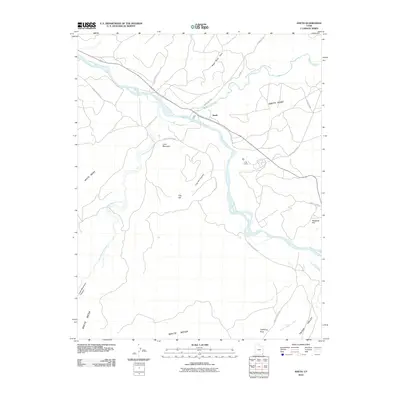
2010 Map of Aneth
USGS Topo · Published 2010About this map
Aneth serves as a focal point in this high-desert landscape where the San Juan River meets McElmo Creek. The topography is defined by significant elevations like White Mesa and Aneth Point, illustrating the deep erosion patterns characteristic of the region. A network of routes, including the Old Aneth Cutoff and Indian Rte 5068, connects the settlement to the surrounding plateaus and canyons. The presence of Lightning Rock and landmarks such as Lone Mountain suggest a landscape used for both navigation and livestock movement. Further south, the map details the transition into Tsitah Valley and the drainage of Tsitah Wash, highlighting the complex hydrology of this arid environment. This 2010 survey reflects the modern road infrastructure while preserving the names of traditional geographic markers that have defined this corner of Utah for generations.
Find a feature on this map
26 named features on this map. Tap any name to fly to it.
Don’t see what you’re looking for? This feature index may not catch every label — zoom into the map to look around manually.
Map Details
Editions of this 2010 Aneth Map
This is the sole edition of this map. No revisions or reprints were ever made.
Other maps of this area

1886 · Abajo
USGS Topo · 1:250,000

1892 · Abajo
USGS Topo · 1:250,000

1893 · Abajo
USGS Topo · 1:250,000

1956 · Cortez
USGS Topo · 1:250,000

1958 · Cortez
USGS Topo · 1:250,000

1958 · Aneth 1 SW
USGS Topo · 1:24,000
1958 · Aneth 1 SE
USGS Topo · 1:24,000

1958 · Cajon Mesa
USGS Topo · 1:62,500

1959 · Cortez
USGS Topo · 1:250,000

1962 · Cortez
USGS Topo · 1:250,000