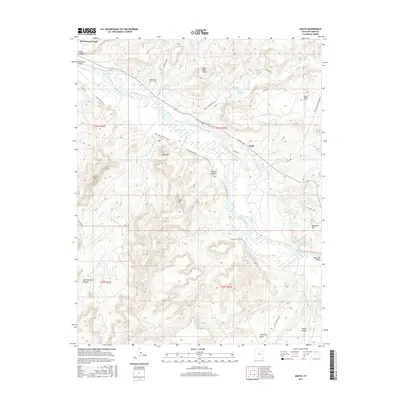
2017 Map of Aneth
USGS Topo · Published 2017About this map
The San Juan River defines the heart of this landscape, carving a winding path through the San Juan Valley and creating a complex network of canyons and plateaus. Near the settlement of Aneth, the Aneth Area Bulals Cem serves as a significant local landmark, situated just north of the river. The topography is dominated by prominent elevations such as Lone Mtn, Clay Hill, and Black Rock Point, which overlook the braided channels of the river.
Find a feature on this map
41 named features on this map. Tap any name to fly to it.
Don’t see what you’re looking for? This feature index may not catch every label — zoom into the map to look around manually.
Map Details
Editions of this 2017 Aneth Map
This is the sole edition of this map. No revisions or reprints were ever made.
Other maps of this area

1886 · Abajo
USGS Topo · 1:250,000

1892 · Abajo
USGS Topo · 1:250,000

1893 · Abajo
USGS Topo · 1:250,000

1956 · Cortez
USGS Topo · 1:250,000

1958 · Cortez
USGS Topo · 1:250,000

1958 · Aneth 1 SW
USGS Topo · 1:24,000
1958 · Aneth 1 SE
USGS Topo · 1:24,000

1958 · Cajon Mesa
USGS Topo · 1:62,500

1959 · Cortez
USGS Topo · 1:250,000

1962 · Cortez
USGS Topo · 1:250,000