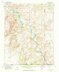
1962 Map of Aneth
USGS Topo · Published 1964About this map
The San Juan River defines the heart of this landscape, cutting through high mesas where the Navajo Indian Reservation meets the Ute Mountain Indian Reservation. In the early 1960s, the settlement of Aneth served as a focal point for the region, complete with an Airstrip, a Cemetery, and access to the Aneth Road. Human history here spans centuries, evidenced by the proximity of modern infrastructure like the Pipeline to ancient Cliff Dwellings and scattered Ruins found near McElmo Creek. Distinctive landforms such as Peters Nipple, Three Gray Hills, and Lone Mountain punctuate the arid terrain, while deep washes like Tsitah Wash and Coyote Wash reveal the erosive power of the desert environment. For researchers, the map provides a look at the intersection of traditional land use and mid-century resource extraction, marked by numerous drill holes and flowing wells throughout the mesas.
Find a feature on this map
49 named features on this map. Tap any name to fly to it.
Don’t see what you’re looking for? This feature index may not catch every label — zoom into the map to look around manually.
Map Details
Editions of this 1962 Aneth Map
This is the sole edition of this map. No revisions or reprints were ever made.
Other maps of this area

1886 · Abajo
USGS Topo · 1:250,000

1889 · Chaco
USGS Topo · 1:250,000

1892 · Abajo
USGS Topo · 1:250,000

1892 · Chaco
USGS Topo · 1:250,000

1892 · Canyon De Chelly
USGS Topo · 1:250,000

1893 · Abajo
USGS Topo · 1:250,000

1934 · Rattlesnake
USGS Topo · 1:62,500

1937 · Rattlesnake
USGS Topo · 1:62,500

1953 · Pastora Peak NW
USGS Topo · 1:24,000

1953 · Dinne Mesa NE
USGS Topo · 1:24,000