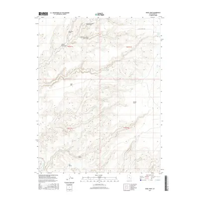
2017 Map of Angel Point
USGS Topo · Published 2017About this map
Robbers Roost Canyon and its complex system of tributaries, including the North Fork, Middle Fork, and White Roost Canyon, dominate this desert landscape. The canyon system's isolation is underscored by labels like No Mans Canyon and Larry Canyon, which feed into the wider basin. Human activity is centered around essential water sources like Robbers Roost Spring and Lost Spring, while the name Bull Pasture indicates the area's grazing history. To the south, the Dirty Devil River carves through the terrain below the prominence of Angel Point. The presence of Oil Well Rd/Roost House in the northeast suggests early industrial exploration in this sparsely populated region of Wayne County.
Find a feature on this map
16 named features on this map. Tap any name to fly to it.
Don’t see what you’re looking for? This feature index may not catch every label — zoom into the map to look around manually.
Map Details
Editions of this 2017 Angel Point Map
This is the sole edition of this map. No revisions or reprints were ever made.
Other maps of this area

1885 · San Rafael
USGS Topo · 1:250,000

1952 · Bull Mountain
USGS Topo · 1:62,500

1953 · Orange Cliffs 3 NE
USGS Topo · 1:24,000

1953 · Orange Cliffs 3 NW
USGS Topo · 1:24,000

1953 · Fiddler Butte
USGS Topo · 1:62,500

1956 · Salina
USGS Topo · 1:250,000

1960 · Salina
USGS Topo · 1:250,000

1962 · Salina
USGS Topo · 1:250,000

1963 · Robbers Roost Canyon
USGS Topo · 1:62,500
1963 · Hanksville
USGS Topo · 1:62,500