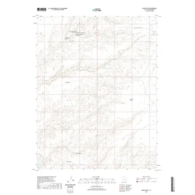
2020 Map of Angel Point
USGS Topo · Published 2020About this map
Robbers Roost Canyon and its various forks dominate this high desert landscape in Wayne County, where the intricate drainage network eventually meets the Dirty Devil River in the southwest. The terrain is defined by deep incisions like No Mans Canyon and Larry Canyon, which carve through the plateau. These natural features have long dictated the movement of people through this environment, as evidenced by the namesake Robbers Roost Spring and the nearby Oil Well Rd/Roost House.
Find a feature on this map
13 named features on this map. Tap any name to fly to it.
Don’t see what you’re looking for? This feature index may not catch every label — zoom into the map to look around manually.
Map Details
Editions of this 2020 Angel Point Map
This is the sole edition of this map. No revisions or reprints were ever made.
Other maps of this area

1885 · San Rafael
USGS Topo · 1:250,000

1952 · Bull Mountain
USGS Topo · 1:62,500

1953 · Orange Cliffs 3 NE
USGS Topo · 1:24,000

1953 · Orange Cliffs 3 NW
USGS Topo · 1:24,000

1953 · Fiddler Butte
USGS Topo · 1:62,500

1956 · Salina
USGS Topo · 1:250,000

1960 · Salina
USGS Topo · 1:250,000

1962 · Salina
USGS Topo · 1:250,000

1963 · Robbers Roost Canyon
USGS Topo · 1:62,500
1963 · Hanksville
USGS Topo · 1:62,500