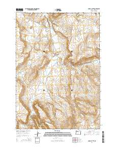
2014 Map of Angell Butte
USGS Topo · Published 2014About this map
Grindstone Cr and its tributaries define the drainage patterns of this high-elevation landscape in eastern Oregon. The terrain is marked by distinctive flat-topped mesas and volcanic features, including Ryegrass Table, Shaw Table, and Forbes Butte. Water management is central to the land's utility, as evidenced by a network of small impoundments such as Layton Reservoir Number 2, Gollum Reservoir, and Brennan Reservoir. These features, along with scattered water sources like Davin Spring and Coyote Spring, suggest a landscape historically tied to livestock grazing. The transition between the high plateaus and lower drainage basins is clearly visible at Axtell Gap and along the prominent Yreka Rim, providing a clear view of the topographic shifts that dictate travel and access through the region.
Find a feature on this map
31 named features on this map. Tap any name to fly to it.
Don’t see what you’re looking for? This feature index may not catch every label — zoom into the map to look around manually.
Map Details
Editions of this 2014 Angell Butte Map
This is the sole edition of this map. No revisions or reprints were ever made.
Other maps of this area

1932 · Dayville
USGS Topo · 1:125,000

1936 · Dayville
USGS Topo · 1:125,000

1955 · Burns
USGS Topo · 1:250,000

1955 · Canyon City
USGS Topo · 1:250,000

1958 · Burns
USGS Topo · 1:250,000

1959 · Burns
USGS Topo · 1:250,000

1959 · Canyon City
USGS Topo · 1:250,000

1961 · Delintment Lake
USGS Topo · 1:62,500
1981 · Powell Mtn
USGS Topo · 1:24,000

1981 · Suplee
USGS Topo · 1:24,000