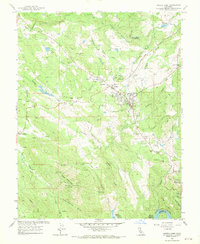
1962 Map of Angels Camp
USGS Topo · Published 1970About this map
Angels Camp serves as the focal point for this early 1960s study of the Mother Lode region, where the town's mining legacy remains etched into the landscape through dozens of named shafts and pits. The dense concentration of industry is centered around the Utica Mine and Lightner Mine, with the Utica Ditch and Ross Reservoir illustrating the extensive water infrastructure required to support these operations. Local community life is anchored by landmarks such as Mark Twain Sch, Bret Harte HS, and the Frogtown fairgrounds.
Find a feature on this map
68 named features on this map. Tap any name to fly to it.
Don’t see what you’re looking for? This feature index may not catch every label — zoom into the map to look around manually.
Map Details
Editions of this 1962 Angels Camp Map
4 editions found
Other maps of this area

1889 · Jackson
USGS Topo · 1:125,000

1891 · Big Trees
USGS Topo · 1:125,000

1892 · Jackson
USGS Topo · 1:125,000

1893 · Sonora
USGS Topo · 1:125,000

1894 · Big Trees
USGS Topo · 1:125,000

1896 · Sonora
USGS Topo · 1:125,000

1897 · Jackson
USGS Topo · 1:125,000

1897 · Sonora
USGS Topo · 1:125,000

1897 · Big Trees
USGS Topo · 1:125,000

1898 · Sonora
USGS Topo · 1:125,000