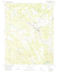
1962 Map of Angels Camp
USGS Topo · Published 1985About this map
Angels Camp serves as the central hub of this Gold Country landscape, where the legacy of hard-rock mining is etched into the terrain. The map documents an intensive industrial history through a dense concentration of workings, including the Gold Cliff Mine, Lightner Mine, and Angels Mine near the town center. Educational landmarks like Bret Harte HS and Mark Twain Sch anchor the community, while the Frogtown fairgrounds suggest the area's enduring cultural significance.
Find a feature on this map
67 named features on this map. Tap any name to fly to it.
Don’t see what you’re looking for? This feature index may not catch every label — zoom into the map to look around manually.
Map Details
Editions of this 1962 Angels Camp Map
4 editions found
Other maps of this area

1889 · Jackson
USGS Topo · 1:125,000

1891 · Big Trees
USGS Topo · 1:125,000

1892 · Jackson
USGS Topo · 1:125,000

1893 · Sonora
USGS Topo · 1:125,000

1894 · Big Trees
USGS Topo · 1:125,000

1896 · Sonora
USGS Topo · 1:125,000

1897 · Jackson
USGS Topo · 1:125,000

1897 · Sonora
USGS Topo · 1:125,000

1897 · Big Trees
USGS Topo · 1:125,000

1898 · Sonora
USGS Topo · 1:125,000