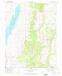
1970 Map of Angle
USGS Topo · Published 1972About this map
Otter Creek Reservoir dominates the western edge of this landscape, its waters contained by a dam at a spillway elevation of 6372. To the east, the terrain rises sharply into the high plateaus of Parker Mountain and the dense timber of the Dixie National Forest. Small settlements like Angle and the northern outskirts of Antimony flank the reservoir, connected by a network of unimproved roads and specialized infrastructure like the Antimony Airstrip. The interior backcountry is marked by cattle-country landmarks such as Nicks Cabin, Clause Pond, and various water sources like Forshea Spring and Billy Spring. This 1970 field-checked survey highlights the transition from the irrigated valley floor to the high, arid overlooks of Forshea Point and Nicks Point, where a labyrinth of jeep trails and pack trails provides the only access through the draws and passes of the central range.
Find a feature on this map
31 named features on this map. Tap any name to fly to it.
Don’t see what you’re looking for? This feature index may not catch every label — zoom into the map to look around manually.
Map Details
Editions of this 1970 Angle Map
This is the sole edition of this map. No revisions or reprints were ever made.
Other maps of this area

1885 · Beaver
USGS Topo · 1:250,000

1885 · Fish Lake
USGS Topo · 1:250,000

1896 · Fish Lake
USGS Topo · 1:250,000

1945 · Marysvale
USGS Topo · 1:62,500

1947 · Marysvale
USGS Topo · 1:62,500

1953 · Richfield
USGS Topo · 1:250,000

1956 · Salina
USGS Topo · 1:250,000

1958 · Richfield
USGS Topo · 1:250,000

1960 · Salina
USGS Topo · 1:250,000

1962 · Salina
USGS Topo · 1:250,000