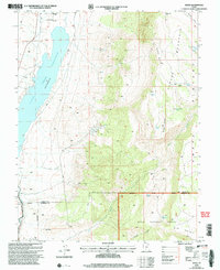
2002 Map of Angle
USGS Topo · Published 2005About this map
The Otter Creek Reservoir dominates this high-altitude landscape where the water is contained by a spillway at an elevation of 6372 feet. This 2002 revision shows a region defined by dramatic verticality, as the western valley floor gives way to the rising slopes of Parker Mountain and the expansive Awapa Plateau to the east. The map captures the remote settlement of Angle and the Antimony Airstrip tucked into the valley, while the higher elevations are marked by seasonal grazing sites like Nicks Cabin and several isolated water sources such as Big Point Spring and Forshea Spring. The southern portion of the sheet transitions into the Dixie National Forest and the Escalante Ranger District, where East Fork Antimony Creek marks the rugged boundary between Piute and Garfield counties. Numerous 4WD tracks and trails traverse the peaks of Forshea Point and Nicks Point, reflecting the area's continued use for land management and recreation.
Find a feature on this map
32 named features on this map. Tap any name to fly to it.
Don’t see what you’re looking for? This feature index may not catch every label — zoom into the map to look around manually.
Map Details
Editions of this 2002 Angle Map
This is the sole edition of this map. No revisions or reprints were ever made.
Other maps of this area

1885 · Beaver
USGS Topo · 1:250,000

1885 · Fish Lake
USGS Topo · 1:250,000

1896 · Fish Lake
USGS Topo · 1:250,000

1945 · Marysvale
USGS Topo · 1:62,500

1947 · Marysvale
USGS Topo · 1:62,500

1953 · Richfield
USGS Topo · 1:250,000

1956 · Salina
USGS Topo · 1:250,000

1958 · Richfield
USGS Topo · 1:250,000

1960 · Salina
USGS Topo · 1:250,000

1962 · Salina
USGS Topo · 1:250,000