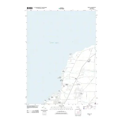
2010 Map of Angola
USGS Topo · Published 2010About this map
The Lake Erie shoreline of Erie County defines this landscape, where the waters meet the coastal communities of Evans. The village of Angola sits inland, connected to the lakefront by a network of local roads including Hardpan Rd and Pontiac Rd. Along the coast, a cluster of summer camps and recreational landmarks suggests a long history of seasonal retreat, featuring Camp Lakeland, Camp Pioneer, and the Saint Vincent de Paul Camp.
Find a feature on this map
39 named features on this map. Tap any name to fly to it.
Don’t see what you’re looking for? This feature index may not catch every label — zoom into the map to look around manually.
Map Details
Editions of this 2010 Angola Map
This is the sole edition of this map. No revisions or reprints were ever made.
Other maps of this area

1894 · Buffalo
USGS Topo · 1:62,500

1899 · Silver Creek
USGS Topo · 1:62,500

1901 · Buffalo
USGS Topo · 1:62,500

1905 · Eden
USGS Topo · 1:62,500

1907 · Eden
USGS Topo · 1:62,500

1943 · Silver Creek
USGS Topo · 1:24,000

1944 · Eden
USGS Topo · 1:62,500

1944 · North Collins
USGS Topo · 1:31,680
1944 · Angola
USGS Topo · 1:31,680

1944 · Farnham
USGS Topo · 1:31,680