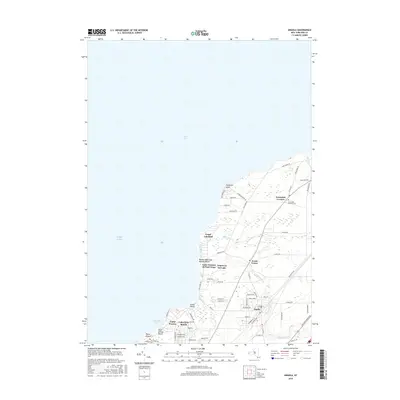
2016 Map of Angola
USGS Topo · Published 2016About this map
Angola and the surrounding Erie County lakeside communities are defined by their position along the eastern shores of Lake Erie. This 2016 survey documents the residential and recreational density that characterizes the area, from the inland center of Angola to the beachside developments at Angola on the Lake and Grandview Bay. The landscape is etched by a series of waterways, most notably Big Sister Creek and Little Sister Cr, which flow toward the lakefront. Long-standing local landmarks like Jerusalem Corners and the adjacent Jerusalem Corners Cem provide genealogical anchor points for researchers, while the CSX rail line serves as a reminder of the corridor's transport history. The transition from established town centers like Evans Center to seasonal or youth-focused sites such as Camp Pioneer and Saint Vincent de Paul Camp reflects the region's dual identity as both a suburban residence and a traditional lakeside retreat.
Find a feature on this map
66 named features on this map. Tap any name to fly to it.
Don’t see what you’re looking for? This feature index may not catch every label — zoom into the map to look around manually.
Map Details
Editions of this 2016 Angola Map
This is the sole edition of this map. No revisions or reprints were ever made.
Other maps of this area

1894 · Buffalo
USGS Topo · 1:62,500

1899 · Silver Creek
USGS Topo · 1:62,500

1901 · Buffalo
USGS Topo · 1:62,500

1905 · Eden
USGS Topo · 1:62,500

1907 · Eden
USGS Topo · 1:62,500

1943 · Silver Creek
USGS Topo · 1:24,000

1944 · Eden
USGS Topo · 1:62,500

1944 · North Collins
USGS Topo · 1:31,680
1944 · Angola
USGS Topo · 1:31,680

1944 · Farnham
USGS Topo · 1:31,680