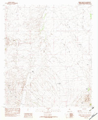
1982 Map of Animas Peak NE
USGS Topo · Published 1982About this map
Animas Creek flows northward through this high-desert landscape of Hidalgo County, tracing a path between the eastern slopes of the Animas Mountains and the surrounding drainage basins. This early 1980s survey captures a sparse ranching and water-management infrastructure, characterized by numerous stock tanks and water sources essential for life in the arid New Mexico bootheel. The presence of Double Adobes and the Middle Wells site indicates the importance of established points for settlement and livestock management.
Find a feature on this map
18 named features on this map. Tap any name to fly to it.
Don’t see what you’re looking for? This feature index may not catch every label — zoom into the map to look around manually.
Map Details
Editions of this 1982 Animas Peak NE Map
This is the sole edition of this map. No revisions or reprints were ever made.
Other maps of this area

1918 · Walnut Wells
USGS Topo · 1:62,500

1918 · Playas
USGS Topo · 1:62,500

1918 · Animas Peak
USGS Topo · 1:62,500

1918 · Pratt
USGS Topo · 1:62,500

1919 · Pratt
USGS Topo · 1:62,500

1919 · Playas
USGS Topo · 1:62,500

1920 · Animas Peak
USGS Topo · 1:62,500

1923 · Walnut Wells
USGS Topo · 1:62,500

1955 · Douglas
USGS Topo · 1:250,000

1959 · Douglas
USGS Topo · 1:250,000