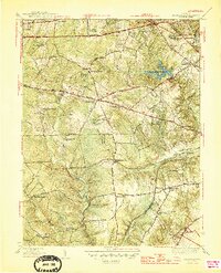
1945 Map of Annandale
USGS Topo · Published 1945About this map
Annandale and its neighboring residential clusters sit at the heart of this mid-1940s landscape, revealing a period of transition before the heavy suburbanization of Northern Virginia. The map details a network of established roads like Lee Highway, Little River Turnpike, and Braddock Road that connect scattered communities such as Lincolnia and Merrifield. At Springfield Sta, the Southern railroad provides a vital transportation link, while the presence of landmarks like Coast Guard Radio Sta and Camp Kiwanis indicates a mix of government and recreational land use during the war years.
Find a feature on this map
77 named features on this map. Tap any name to fly to it.
Don’t see what you’re looking for? This feature index may not catch every label — zoom into the map to look around manually.
Map Details
Editions of this 1945 Annandale Map
2 editions found
Other maps of this area

1890 · Mt. Vernon
USGS Topo · 1:125,000

1891 · Mt. Vernon
USGS Topo · 1:125,000

1894 · Mt. Vernon
USGS Topo · 1:125,000

1897 · Mt. Vernon
USGS Topo · 1:125,000

1900 · Washington
USGS Topo · 1:62,500

1913 · Indian Head
USGS Topo · 1:62,500

1915 · Fairfax
USGS Topo · 1:62,500

1923 · Indian Head
USGS Topo · 1:48,000

1925 · Indian Head
USGS Topo · 1:62,500

1927 · Quantico
USGS Topo · 1:62,500