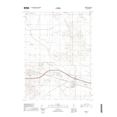
2018 Map of Annawan
USGS Topo · Published 2018About this map
Atkinson and Annawan anchor this agricultural landscape in Henry County, where the transition between the Green River and Mud Creek systems reveals an intensive history of drainage engineering. The map documents an intricate network of waterways designed to reclaim the fertile prairie soil, including the Shabbona Special Ditch, Main Union Special Ditch, and several numbered ditches that define the township sections. These man-made channels tell the story of the region’s development into a premier farming district.
Find a feature on this map
70 named features on this map. Tap any name to fly to it.
Don’t see what you’re looking for? This feature index may not catch every label — zoom into the map to look around manually.
Map Details
Editions of this 2018 Annawan Map
This is the sole edition of this map. No revisions or reprints were ever made.
Other maps of this area

1899 · Clinton
USGS Topo · 1:125,000

1929 · Annawan
USGS Topo · 1:62,500

1932 · Prophetstown
USGS Topo · 1:48,000

1932 · Annawan
USGS Topo · 1:62,500

1934 · Geneseo
USGS Topo · 1:62,500

1936 · Prophetstown
USGS Topo · 1:62,500

1952 · Erie
USGS Topo · 1:62,500

1953 · German Corner
USGS Topo · 1:24,000
1953 · Atkinson
USGS Topo · 1:24,000

1958 · Davenport
USGS Topo · 1:250,000