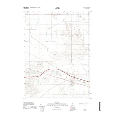
2021 Map of Annawan
USGS Topo · Published 2021About this map
The agrarian landscape of Henry County is defined by an extensive network of drainage infrastructure designed to manage the fertile lowlands between the Green River and Mud Creek. Dozens of engineered channels, including the Main Union Special Ditch, Shabbona Special Ditch, and Mineral Marsh Ditch, crisscross the township lines, revealing the intensive land reclamation efforts required for local agriculture. The settlements of Atkinson and Annawan serve as the primary hubs along the southern corridor, connected by the historical alignment of Us HWY 6 and the modern path of I-80. Smaller landmarks such as Spath Spur and Sacred Heart Cem provide localized points of reference for genealogists and local historians. This modern survey reflects the enduring grid of county roads and the specialized water management systems that have sustained these prairie communities into the twenty-first century.
Find a feature on this map
62 named features on this map. Tap any name to fly to it.
Don’t see what you’re looking for? This feature index may not catch every label — zoom into the map to look around manually.
Map Details
Editions of this 2021 Annawan Map
This is the sole edition of this map. No revisions or reprints were ever made.
Other maps of this area

1899 · Clinton
USGS Topo · 1:125,000

1929 · Annawan
USGS Topo · 1:62,500

1932 · Prophetstown
USGS Topo · 1:48,000

1932 · Annawan
USGS Topo · 1:62,500

1934 · Geneseo
USGS Topo · 1:62,500

1936 · Prophetstown
USGS Topo · 1:62,500

1952 · Erie
USGS Topo · 1:62,500

1953 · German Corner
USGS Topo · 1:24,000
1953 · Atkinson
USGS Topo · 1:24,000

1958 · Davenport
USGS Topo · 1:250,000