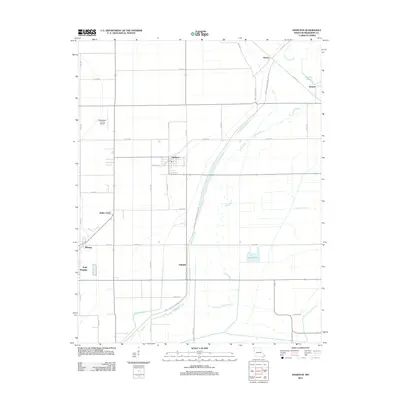
2012 Map of Anniston
USGS Topo · Published 2012About this map
Anniston and the surrounding agricultural lowlands of the Missouri Bootheel define this landscape, where a complex network of drainage ditches and levees manages the Mississippi River floodplain. The area is characterized by organized rural settlements and small agricultural hubs like Whiting and Samos. Water management infrastructure is prominent throughout the terrain, featuring the Birds Point New Madrid Levee Rd and the Wolf Hole Lateral, which carve through the land alongside natural features like Black Bayou and James Bayou.
Find a feature on this map
42 named features on this map. Tap any name to fly to it.
Don’t see what you’re looking for? This feature index may not catch every label — zoom into the map to look around manually.
Map Details
Editions of this 2012 Anniston Map
This is the sole edition of this map. No revisions or reprints were ever made.
Other maps of this area

1939 · Wickliffe
USGS Topo · 1:62,500

1939 · Charleston
USGS Topo · 1:62,500

1939 · Hickman
USGS Topo · 1:62,500

1939 · Bayouville
USGS Topo · 1:62,500

1951 · Wolf Island
USGS Topo · 1:24,000

1951 · Wickliffe SW
USGS Topo · 1:24,000

1952 · Wickliffe
USGS Topo · 1:62,500

1954 · Charleston
USGS Topo · 1:62,500

1954 · Hickman
USGS Topo · 1:62,500
1955 · Hickman
USGS Topo · 1:62,500