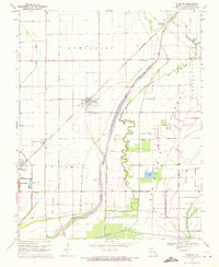
1969 Map of Anniston
USGS Topo · Published 1971About this map
The Birds Point New Madrid Floodway dominates the eastern half of this Mississippi County landscape, showing the complex drainage and flood control engineering of the late 1960s. The St Louis Southwestern railroad corridor serves as the primary spine for development, connecting the central hub of Anniston with surrounding settlements like Whiting and the outskirts of East Prairie.
Find a feature on this map
29 named features on this map. Tap any name to fly to it.
Don’t see what you’re looking for? This feature index may not catch every label — zoom into the map to look around manually.
Map Details
Editions of this 1969 Anniston Map
This is the sole edition of this map. No revisions or reprints were ever made.
Other maps of this area

1939 · Wickliffe
USGS Topo · 1:62,500

1939 · Charleston
USGS Topo · 1:62,500

1939 · Hickman
USGS Topo · 1:62,500

1939 · Bayouville
USGS Topo · 1:62,500

1951 · Wolf Island
USGS Topo · 1:24,000

1951 · Wickliffe SW
USGS Topo · 1:24,000

1952 · Wickliffe
USGS Topo · 1:62,500

1954 · Charleston
USGS Topo · 1:62,500

1954 · Hickman
USGS Topo · 1:62,500
1955 · Hickman
USGS Topo · 1:62,500