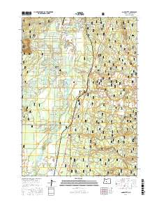
2017 Map of Anns Butte
USGS Topo · Published 2017About this map
The Deschutes River and its tributary, the Little Deschutes River, create a complex network of wetlands and oxbows through the heart of this central Oregon landscape. This area includes the developed communities of Sunriver and Three Rivers, where residential road networks like Azusa Rd and Skyline Rd meet the edge of the Deschutes National Forest. Significant transportation infrastructure facilitates river crossings, including the Harper Bridge and the Montgomery Bridge. Cultural and geological markers are found throughout, from the Harper Cem near the Sunriver Airport to the broad slopes of Anns Butte and the northern reaches of the Newberry Volcano. The southern portion of the map transitions into the more open Paulina Prairie, where Paulina Cr flows toward the primary river system.
Find a feature on this map
80 named features on this map. Tap any name to fly to it.
Don’t see what you’re looking for? This feature index may not catch every label — zoom into the map to look around manually.
Map Details
Editions of this 2017 Anns Butte Map
This is the sole edition of this map. No revisions or reprints were ever made.
Other maps of this area

1930 · Maiden Peak
USGS Topo · 1:125,000

1931 · Newberry Crater
USGS Topo · 1:125,000

1934 · Maiden Peak
USGS Topo · 1:125,000

1935 · Newberry Crater
USGS Topo · 1:125,000

1955 · Crescent
USGS Topo · 1:250,000

1957 · Crescent
USGS Topo · 1:250,000

1958 · Crescent
USGS Topo · 1:250,000
1963 · Lava Cast Forest
USGS Topo · 1:24,000
1963 · Lava Butte
USGS Topo · 1:24,000
1963 · Benham Falls
USGS Topo · 1:24,000