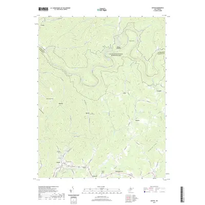
2019 Map of Ansted
USGS Topo · Published 2019About this map
Ansted and the surrounding Fayette County uplands are defined by the deep, winding gorge of the Gauley River. This 2019 survey documents a landscape of dramatic elevation shifts, where high points like Bearwallow Knob overlook a network of whitewater, including the vividly named Pure Screaming Hell Rapids and Heaven Help You Rapids near Koontz Bend. The settlement pattern follows the ridgelines and creek hollows, with older communities like Victor, Mountain Cove, and Marvel linked by historic routes such as the Midland Trl. For the local historian, the map provides precise locations for several regional burial grounds, including Westlake Cem, Mount Chapel Cem, and Restlawn Memory Gardens. The transition from the river bottom at Peters Junction to the high Dogwood Ridge illustrates the geographic complexity that shaped the development of these Appalachian coal and timber communities.
Find a feature on this map
85 named features on this map. Tap any name to fly to it.
Don’t see what you’re looking for? This feature index may not catch every label — zoom into the map to look around manually.
Map Details
Editions of this 2019 Ansted Map
This is the sole edition of this map. No revisions or reprints were ever made.
Other maps of this area

1889 · Nicholas
USGS Topo · 1:125,000

1891 · Nicholas
USGS Topo · 1:125,000

1897 · Kanawha Falls
USGS Topo · 1:125,000

1900 · Kanawha Falls
USGS Topo · 1:125,000

1901 · Nicholas
USGS Topo · 1:125,000

1901 · Kanawha Falls
USGS Topo · 1:125,000

1908 · Clay
USGS Topo · 1:48,000

1908 · Fayetteville
USGS Topo · 1:48,000

1910 · Clay
USGS Topo · 1:62,500

1910 · Fayetteville
USGS Topo · 1:62,500