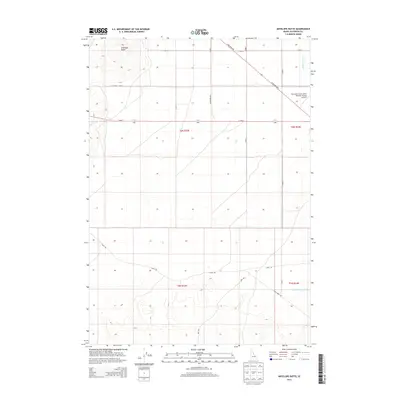
2013 Map of Antelope Butte
USGS Topo · Published 2013About this map
Antelope Butte rises as the primary landmark in this section of Jefferson County, providing a high-ground anchor for a landscape defined by an extensive irrigation network. The presence of the Comstock Canal, Crystal Lake Canal, and Second Owsley Canal reflects the region's historical reliance on engineering to manage water for agricultural and local use. In the northeastern corner, the Mud Lake Airport (West Jefferson County Airport) serves as a localized hub for the community. The grid of roads, including N Salmon Hwy and Canal Rd, illustrates the transition between open high-desert terrain and the coordinated development of the early twenty-first century.
Find a feature on this map
16 named features on this map. Tap any name to fly to it.
Don’t see what you’re looking for? This feature index may not catch every label — zoom into the map to look around manually.
Map Details
Editions of this 2013 Antelope Butte Map
This is the sole edition of this map. No revisions or reprints were ever made.
Other maps of this area

1955 · Idaho Falls
USGS Topo · 1:250,000

1958 · Idaho Falls
USGS Topo · 1:250,000

1964 · Kettle Butte NW
USGS Topo · 1:24,000

1964 · Terreton
USGS Topo · 1:24,000

1964 · Mud Lake NW
USGS Topo · 1:24,000

1969 · Antelope Butte
USGS Topo · 1:24,000

1969 · Circular Butte
USGS Topo · 1:24,000

1969 · Circular Butte NW
USGS Topo · 1:24,000
1969 · Monteview
USGS Topo · 1:24,000

1973 · Little Butte NE
USGS Topo · 1:24,000