
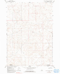
1964 Map of Kettle Butte NW
USGS Topo · Published 1965About this map
National Reactor Testing Station occupies a significant portion of this high-desert landscape in southeastern Idaho as it appeared in the mid-1960s. The terrain is defined by undulating basalt flows and scattered buttes, primarily within the secure boundaries of this federal atomic research installation. The map documents the jurisdictional divide between Jefferson Co and Bonneville Co, illustrating how these administrative lines intersect with the vast, undeveloped expanses used for nuclear reactor development. Aside from the occasional unimproved dirt track and bench marks such as BM 5075 and BM 4894, the sheet remains largely devoid of residential or agricultural development, preserving a specific era of cold-war era scientific land use and its topographical isolation.
Find a feature on this map
2 named features on this map. Tap any name to fly to it.
Don’t see what you’re looking for? This feature index may not catch every label — zoom into the map to look around manually.
Map Details
Editions of this 1964 Kettle Butte NW Map
2 editions found
Other maps of this area

1955 · Idaho Falls
USGS Topo · 1:250,000

1958 · Idaho Falls
USGS Topo · 1:250,000

1964 · Kettle Butte NE
USGS Topo · 1:24,000

1964 · Kettle Butte SW
USGS Topo · 1:24,000

1964 · Terreton
USGS Topo · 1:24,000
1964 · Butterfly Butte
USGS Topo · 1:24,000

1964 · Mud Lake SE
USGS Topo · 1:24,000

1969 · Antelope Butte
USGS Topo · 1:24,000

1973 · Little Butte NE
USGS Topo · 1:24,000

1973 · Little Butte
USGS Topo · 1:24,000