
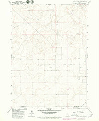
1964 Map of Kettle Butte NE
USGS Topo · Published 1965About this map
The county line between Jefferson Co and Bonneville Co divides this high-desert landscape in southeastern Idaho, surveyed in the mid-1960s. The area is defined by its arid character and a critical dependence on subterranean water resources, indicated by the numerous numbered wells scattered across the terrain. These infrastructure points, such as Well 4906 and Well 4972, highlight the development of the region for ranching or agricultural use in a place where surface water is nearly absent. The Brush-covered expanse is largely undeveloped, though a few unimproved dirt roads and light-duty paths provide the only transit through the hills. To the southeast, the Kettle Butte Drain offers a rare named drainage feature, showing the start of water management efforts in this part of the Snake River Plain.
Find a feature on this map
12 named features on this map. Tap any name to fly to it.
Don’t see what you’re looking for? This feature index may not catch every label — zoom into the map to look around manually.
Map Details
Editions of this 1964 Kettle Butte NE Map
2 editions found
Other maps of this area

1949 · Roberts
USGS Topo · 1:62,500

1949 · Roberts
USGS Topo · 1:24,000

1949 · Shattuck Butte
USGS Topo · 1:24,000

1950 · Shattuck Butte
USGS Topo · 1:24,000

1950 · Roberts
USGS Topo · 1:24,000

1955 · Idaho Falls
USGS Topo · 1:250,000

1958 · Idaho Falls
USGS Topo · 1:250,000

1964 · Kettle Butte NW
USGS Topo · 1:24,000

1964 · Kettle Butte SW
USGS Topo · 1:24,000

1964 · Terreton
USGS Topo · 1:24,000