
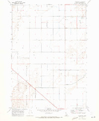
1964 Map of Terreton
USGS Topo · Published 1965About this map
The settlement of Terreton serves as a focal point for this 1960s agricultural and industrial landscape in Jefferson County. Irrigation infrastructure is central to the area's development, evidenced by an extensive network of waterworks including the Crystal Lake Canal, Owsley Canal, and the Second Owsley Canal which divert water toward the surrounding plains. To the north, the North Lake State Wildlife Management Area borders the namesake Mud Lake, while the southern portion of the map is dominated by the sprawling boundaries of the National Reactor Testing Station. This juxtaposition of traditional high-desert farming, managed wetlands, and secretive federal nuclear research facilities illustrates the diverse land use in the Snake River Plain during the mid-20th century. Local landmarks such as the Terre community and various Storage Bins reflect the vital role of grain and water management in this high-altitude environment.
Find a feature on this map
13 named features on this map. Tap any name to fly to it.
Don’t see what you’re looking for? This feature index may not catch every label — zoom into the map to look around manually.
Map Details
Editions of this 1964 Terreton Map
This is the sole edition of this map. No revisions or reprints were ever made.
Other maps of this area

1955 · Idaho Falls
USGS Topo · 1:250,000

1958 · Idaho Falls
USGS Topo · 1:250,000

1964 · Kettle Butte NE
USGS Topo · 1:24,000

1964 · Kettle Butte NW
USGS Topo · 1:24,000

1964 · Mud Lake SE
USGS Topo · 1:24,000

1964 · Mud Lake NW
USGS Topo · 1:24,000

1964 · Rays Lake
USGS Topo · 1:24,000

1969 · Antelope Butte
USGS Topo · 1:24,000
1969 · Monteview
USGS Topo · 1:24,000

1973 · Little Butte NE
USGS Topo · 1:24,000