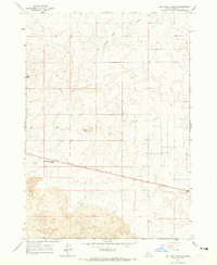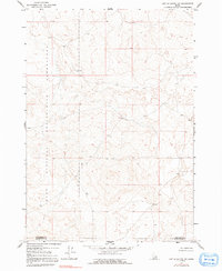
Idaho National Engineering Laboratory dominates the western half of this landscape, marking a period of significant scientific and technological expansion in eastern Idaho during the mid-twentieth century. The terrain is characterized by intricate volcanic topography, featuring numerous small closed depressions and distinct lava flow patterns that define the Snake River Plain. This 1964 field-checked survey reveals a sparsely developed region where the boundary between Jefferson County and Bonneville County cuts across the southeastern corner. The map captures the area before modern infrastructure expanded, preserving the natural state of the basaltic landscape used for government research and engineering operations.
2 named features on this map. Tap any name to fly to it.
Don’t see what you’re looking for? This feature index may not catch every label — zoom into the map to look around manually.
2 editions found
79 maps found

1964 Deer Parks
Jefferson County, ID

1964 Kettle Butte NE
Jefferson County, ID

1964 Kettle Butte NW
Jefferson County, ID

1964 Market Lake
Jefferson County, ID

1964 Market Lake NE
Jefferson County, ID

1964 Mud Lake NW
Jefferson County, ID

1964 Mud Lake SE
Jefferson County, ID

1964 Rays Lake
Jefferson County, ID

1964 Terreton
Jefferson County, ID

1969 Antelope Butte
Jefferson County, ID

1969 Circular Butte NW
Jefferson County, ID

1969 Monteview
Jefferson County, ID

1973 Little Butte NE
Jefferson County, ID

1980 Circular Butte
Jefferson County, ID
2010 Antelope Butte
Jefferson County, ID
2010 Circular Butte NW
Jefferson County, ID
2010 Deer Parks
Jefferson County, ID
2010 Kettle Butte NE
Jefferson County, ID
2010 Kettle Butte NW
Jefferson County, ID
2010 Little Butte NE
Jefferson County, ID
2010 Market Lake
Jefferson County, ID
2010 Market Lake NE
Jefferson County, ID
2010 Monteview
Jefferson County, ID
2010 Mud Lake NW
Jefferson County, ID
2010 Mud Lake SE
Jefferson County, ID
2010 Rays Lake
Jefferson County, ID
2010 Terreton
Jefferson County, ID
2013 Antelope Butte
Jefferson County, ID
2013 Circular Butte NW
Jefferson County, ID
2013 Deer Parks
Jefferson County, ID
2013 Kettle Butte NE
Jefferson County, ID
2013 Kettle Butte NW
Jefferson County, ID
2013 Little Butte NE
Jefferson County, ID
2013 Market Lake
Jefferson County, ID
2013 Market Lake NE
Jefferson County, ID
2013 Monteview
Jefferson County, ID
2013 Mud Lake NW
Jefferson County, ID
2013 Mud Lake SE
Jefferson County, ID
2013 Rays Lake
Jefferson County, ID
2013 Terreton
Jefferson County, ID
2017 Antelope Butte
Jefferson County, ID
2017 Circular Butte NW
Jefferson County, ID
2017 Deer Parks
Jefferson County, ID
2017 Kettle Butte NE
Jefferson County, ID
2017 Kettle Butte NW
Jefferson County, ID
2017 Little Butte NE
Jefferson County, ID
2017 Market Lake
Jefferson County, ID
2017 Market Lake NE
Jefferson County, ID
2017 Monteview
Jefferson County, ID
2017 Mud Lake NW
Jefferson County, ID
2017 Mud Lake SE
Jefferson County, ID
2017 Rays Lake
Jefferson County, ID
2017 Terreton
Jefferson County, ID
2020 Antelope Butte
Jefferson County, ID
2020 Circular Butte NW
Jefferson County, ID
2020 Deer Parks
Jefferson County, ID
2020 Kettle Butte NE
Jefferson County, ID
2020 Kettle Butte NW
Jefferson County, ID
2020 Little Butte NE
Jefferson County, ID
2020 Market Lake
Jefferson County, ID
2020 Market Lake NE
Jefferson County, ID
2020 Monteview
Jefferson County, ID
2020 Mud Lake NW
Jefferson County, ID
2020 Mud Lake SE
Jefferson County, ID
2020 Rays Lake
Jefferson County, ID
2020 Terreton
Jefferson County, ID

2023 Circular Butte NW
Jefferson County, ID

2023 Deer Parks
Jefferson County, ID

2023 Kettle Butte NE
Jefferson County, ID

2023 Kettle Butte NW
Jefferson County, ID

2023 Little Butte NE
Jefferson County, ID

2023 Market Lake
Jefferson County, ID

2023 Market Lake NE
Jefferson County, ID

2023 Monteview
Jefferson County, ID

2023 Mud Lake SE
Jefferson County, ID

2023 Terreton
Jefferson County, ID

2024 Antelope Butte
Jefferson County, ID

2024 Mud Lake NW
Jefferson County, ID

2024 Rays Lake
Jefferson County, ID