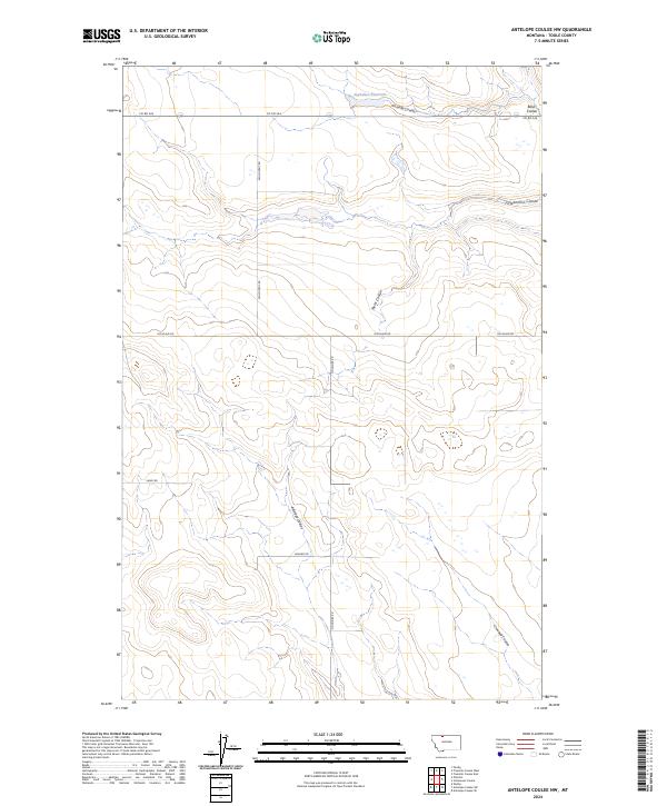
2024 Map of Antelope Coulee NW
USGS Topo · Published 2024About this map
Suphellen Reservoir serves as a primary water landmark in this northern Toole County landscape, where the terrain is defined by a series of drainage systems known locally as coulees. These topographical features, including Picadilly Coulee and Fifteenmile Coulee, reveal the complex natural irrigation and erosion patterns characteristic of the Montana plains. The map details a strictly grid-based rural road network named for local figures or families, such as Woldtvedt Rd, Sauby Rd, and Gus Blaze Rd. These roads reflect the continued agricultural division of the land into townships like t34n r1w. The intersection of natural landmarks like Antelope Coulee with these established county roads provides a clear picture of how modern rural life is structured around the physical geography of the High Plains.
Find a feature on this map
19 named features on this map. Tap any name to fly to it.
Don’t see what you’re looking for? This feature index may not catch every label — zoom into the map to look around manually.
Map Details
Editions of this 2024 Antelope Coulee NW Map
This is the sole edition of this map. No revisions or reprints were ever made.
Other maps of this area

1939 · Sunburst
USGS Topo · 1:62,500

1943 · Antelope Coulee
USGS Topo · 1:62,500

1943 · Shelby
USGS Topo · 1:62,500

1945 · West Butte
USGS Topo · 1:62,500

1954 · Shelby
USGS Topo · 1:250,000

1958 · Shelby
USGS Topo · 1:250,000

1984 · Sweet Grass Hills
USGS Topo · 1:100,000
1986 · Antelope Coulee SW
USGS Topo · 1:24,000
1986 · Shelby
USGS Topo · 1:24,000
1986 · Ferdig
USGS Topo · 1:24,000