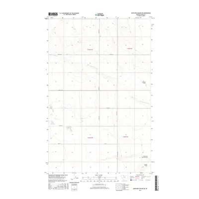
2017 Map of Antelope Coulee SW
USGS Topo · Published 2017About this map
Toole County's high plains terrain is defined by the complex drainage systems of Antelope Coulee and Dunkirk Coulee in this northern Montana landscape. The area is characterized by a sparse network of county roads that follow the township and range lines, including Bronken Rd and King Rd, providing access to the wide-open ranching or dryland farming tracts between t33n r1w and t32n r1e. The intermittent flow of W Fork Willow Cr and the deeply carved North Fork Dunkirk Coulee illustrate the region's erosional patterns, where water has shaped the prairie over millennia. A single utility or industrial marker, Compressor, stands near Jap Evans Rd, hinting at the energy infrastructure that often punctuates these remote sections of the American West. This survey offers a precise look at the 2017 land use and topography of the high plains before the further modernization of rural access ways.
Find a feature on this map
14 named features on this map. Tap any name to fly to it.
Don’t see what you’re looking for? This feature index may not catch every label — zoom into the map to look around manually.
Map Details
Editions of this 2017 Antelope Coulee SW Map
This is the sole edition of this map. No revisions or reprints were ever made.
Other maps of this area

1920 · Conrad
USGS Topo · 1:125,000

1943 · Antelope Coulee
USGS Topo · 1:62,500

1943 · Shelby
USGS Topo · 1:62,500

1954 · Shelby
USGS Topo · 1:250,000

1958 · Shelby
USGS Topo · 1:250,000

1967 · Naismith
USGS Topo · 1:24,000

1967 · South Devon School
USGS Topo · 1:24,000

1967 · Dunkirk
USGS Topo · 1:24,000
1984 · Conrad
USGS Topo · 1:100,000

1984 · Sweet Grass Hills
USGS Topo · 1:100,000