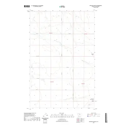
2020 Map of Antelope Coulee SW
USGS Topo · Published 2020About this map
Antelope Coulee and the surrounding drainage basins of Toole County are defined by a high-plains landscape where early 21st-century infrastructure meets a traditional section-line grid. The map area is bisected by the W Fork Willow Cr, which meanders through the central townships. The local road network, including Bronken Rd and the curiously named Gumboe Joe Rd, provides access to this agricultural and industrial territory. A notable industrial marker is the Compressor station located near the center of the quadrangle, signaling the region's involvement in energy transmission or natural gas production. In the southeastern corner, the terrain drops toward Dunkirk Coulee and its North Fork, revealing the intricate erosional patterns typical of the northern Montana plains. This 2020 survey documents the intersection of legacy ranch roads like Jap Evans Rd and modern utilities.
Find a feature on this map
14 named features on this map. Tap any name to fly to it.
Don’t see what you’re looking for? This feature index may not catch every label — zoom into the map to look around manually.
Map Details
Editions of this 2020 Antelope Coulee SW Map
This is the sole edition of this map. No revisions or reprints were ever made.
Other maps of this area

1920 · Conrad
USGS Topo · 1:125,000

1943 · Antelope Coulee
USGS Topo · 1:62,500

1943 · Shelby
USGS Topo · 1:62,500

1954 · Shelby
USGS Topo · 1:250,000

1958 · Shelby
USGS Topo · 1:250,000

1967 · Naismith
USGS Topo · 1:24,000

1967 · South Devon School
USGS Topo · 1:24,000

1967 · Dunkirk
USGS Topo · 1:24,000
1984 · Conrad
USGS Topo · 1:100,000

1984 · Sweet Grass Hills
USGS Topo · 1:100,000