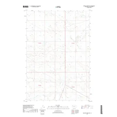
2017 Map of Antelope Creek East
USGS Topo · Published 2017About this map
The S Fork Moreau River cuts through the northern reaches of this Butte County landscape, anchoring a network of intermittent drainage systems that define the high plains of western South Dakota. Moving southward across the township lines of t13n r4e and t13n r5e, the terrain is etched by the courses of Fourmile Cr, Battle Cr, and Antelope Cr. These seasonal watercourses dictate the local topography, creating a series of draws and ridges typical of the Missouri Plateau. Produced by the U.S. Geological Survey using imagery from 2016, this topographic study illustrates the sparse, rural character of the region where section lines and local roads follow the natural contours of the land.
Find a feature on this map
8 named features on this map. Tap any name to fly to it.
Don’t see what you’re looking for? This feature index may not catch every label — zoom into the map to look around manually.
Map Details
Editions of this 2017 Antelope Creek East Map
This is the sole edition of this map. No revisions or reprints were ever made.
Other maps of this area

1906 · Two Top
USGS Topo · 1:62,500

1907 · Belle Fourche
USGS Topo · 1:125,000

1913 · Newell
USGS Topo · 1:125,000

1935 · Hoover
USGS Topo · 1:125,000

1935 · Harding
USGS Topo · 1:125,000

1953 · Rapid City
USGS Topo · 1:250,000

1954 · Lemmon
USGS Topo · 1:250,000

1957 · Lemmon
USGS Topo · 1:250,000

1957 · Rapid City
USGS Topo · 1:250,000
1965 · Two Top Butte West
USGS Topo · 1:24,000