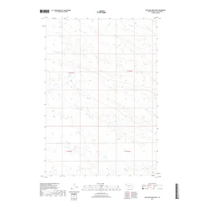
2017 Map of Antelope Creek West
USGS Topo · Published 2017About this map
Antelope Creek and Battle Creek define the drainage patterns across this section of Butte County, where the high plains landscape is marked by subtle topographic relief and seasonal watercourses. This 2017 survey shows a region primarily organized by the Public Land Survey System, as evidenced by the township and range divisions of t13n r3e, t13n r4e, t12n r3e, and t12n r4e. The terrain is characterized by the winding path of Fourmile Creek in the northern reaches, illustrating the natural erosion patterns typical of the western South Dakota prairie. For those studying the geographic distribution of ranching land and water rights, the proximity of these named drainages provides a clear framework for understanding the rural environment of the early 21st century.
Find a feature on this map
7 named features on this map. Tap any name to fly to it.
Don’t see what you’re looking for? This feature index may not catch every label — zoom into the map to look around manually.
Map Details
Editions of this 2017 Antelope Creek West Map
This is the sole edition of this map. No revisions or reprints were ever made.
Other maps of this area

1905 · Indian
USGS Topo · 1:62,500

1906 · Two Top
USGS Topo · 1:62,500

1907 · Belle Fourche
USGS Topo · 1:125,000

1935 · Harding
USGS Topo · 1:125,000

1953 · Rapid City
USGS Topo · 1:250,000

1954 · Lemmon
USGS Topo · 1:250,000

1957 · Lemmon
USGS Topo · 1:250,000

1957 · Rapid City
USGS Topo · 1:250,000
1965 · Antelope Butte
USGS Topo · 1:24,000
1965 · Two Top Butte West
USGS Topo · 1:24,000