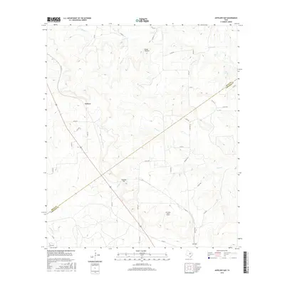
2016 Map of Antelope Gap
USGS Topo · Published 2016About this map
Antelope Gap sits at the heart of this Central Texas landscape, where the broken terrain of the Lampasas Cut Plain meets the agricultural expanses of the Edwards Plateau. The settlement of Scallorn and the southern point of Lee Gap anchor a network of rural roads that navigate the complex drainage systems of Simms Cr and Antelope Cr. This 2016 survey illustrates the persistent rural character of the border between Mills County and Lampasas County, marked by traditional ranching and aviation via the Birchfield Ranch Airport. Prominent landforms like Bread Tray Mtn rise above the winding paths of Bee Cove Cr and Bear Cove Cr, while Clift Lake provides a localized water source in the northeast. The map provides a detailed view of the contemporary road network, including Farm Rd 2942, which facilitates transport across this transition between high ridges and creek bottoms.
Find a feature on this map
38 named features on this map. Tap any name to fly to it.
Don’t see what you’re looking for? This feature index may not catch every label — zoom into the map to look around manually.
Map Details
Editions of this 2016 Antelope Gap Map
This is the sole edition of this map. No revisions or reprints were ever made.
Other maps of this area

1885 · San Saba
USGS Topo · 1:125,000

1887 · Lampasas
USGS Topo · 1:125,000

1894 · Lampasas
USGS Topo · 1:125,000

1894 · San Saba
USGS Topo · 1:125,000

1925 · San Saba 4-a
USGS Topo · 1:48,000

1925 · San Saba 1-d
USGS Topo · 1:48,000

1928 · Goldthwaite
USGS Topo · 1:62,500

1931 · Bend
USGS Topo · 1:62,500

1948 · Goldthwaite
USGS Topo · 1:62,500
1950 · Goldthwaite
USGS Topo · 1:62,500