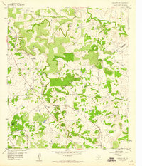
1959 Map of Antelope Gap
USGS Topo · Published 1960About this map
The Gulf Colorado and Santa Fe railroad bisects this Central Texas landscape, following a diagonal path through the high ground between Antelope Creek and Simms Creek. This 1959 survey documents several rural communities and stop-points, including Antelope Gap and Scallorn, which are positioned along the rail line near the Mills Co Lampasas Co border. The topography is defined by significant elevations like Bread Tray Mountain and the deep drainage of Bee Cave Creek and Bear Cove. In the northern part of the quadrangle, the settlement of Pleasant Grove sits on a plateau near the headwaters of North Simms Creek, while the southern edge features the Lometa FAA Radio Towers near Lee Gap. The map captures a moment in the mid-20th century when these small rail-stop communities and ranching outposts like Long Cove remained distinct nodes in the landscape.
Find a feature on this map
16 named features on this map. Tap any name to fly to it.
Don’t see what you’re looking for? This feature index may not catch every label — zoom into the map to look around manually.
Map Details
Editions of this 1959 Antelope Gap Map
This is the sole edition of this map. No revisions or reprints were ever made.
Other maps of this area

1885 · San Saba
USGS Topo · 1:125,000

1887 · Lampasas
USGS Topo · 1:125,000

1894 · Lampasas
USGS Topo · 1:125,000

1894 · San Saba
USGS Topo · 1:125,000

1925 · San Saba 4-a
USGS Topo · 1:48,000

1925 · San Saba 1-d
USGS Topo · 1:48,000

1928 · Goldthwaite
USGS Topo · 1:62,500

1931 · Bend
USGS Topo · 1:62,500

1948 · Goldthwaite
USGS Topo · 1:62,500
1950 · Goldthwaite
USGS Topo · 1:62,500