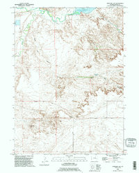
1990 Map of Antelope Gap
USGS Topo · Published 1995About this map
Grayrocks Reservoir dominates the northern reaches of this landscape, where the Laramie River winds through the high plains of Platte County. The topography is defined by the sharp descent into Eagles Nest Canyon and the natural passage of Antelope Gap, features that have historically dictated the movement of livestock and travelers across this arid region. This 1990 revision, based on imagery dating back to the late 1940s, reveals a sparse network of infrastructure including Antelope Gap Road and Slater Road, which navigate the draws and ridges between water sources like Eagles Nest Spring. The presence of a legacy Ditch system and proximity to drainage from Chugwater and Cottonwood creeks highlights the vital importance of water management in sustaining ranching operations within these Wyoming breaks.
Find a feature on this map
11 named features on this map. Tap any name to fly to it.
Don’t see what you’re looking for? This feature index may not catch every label — zoom into the map to look around manually.
Map Details
Editions of this 1990 Antelope Gap Map
This is the sole edition of this map. No revisions or reprints were ever made.
Other maps of this area

1896 · Hartville
USGS Topo · 1:125,000

1901 · Hartville
USGS Topo · 1:125,000

1950 · Register Cliff
USGS Topo · 1:24,000

1951 · Dwyer
USGS Topo · 1:24,000

1951 · Antelope Gap
USGS Topo · 1:24,000
1951 · Wheatland
USGS Topo · 1:24,000
1951 · Wheatland NE
USGS Topo · 1:24,000

1951 · Eagles Nest
USGS Topo · 1:24,000

1952 · Register Cliff
USGS Topo · 1:24,000

1953 · Ferguson Corner
USGS Topo · 1:24,000