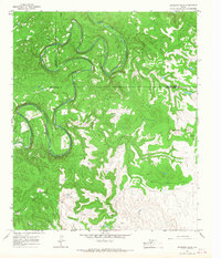
1965 Map of Antelope Hills
USGS Topo · Published 1967About this map
The Clear Fork Brazos River winds in dramatic, tight oxbows across this mid-1960s landscape, carving through the boundary between Shackelford, Haskell, and Throckmorton counties. This region is characterized by a concentrated industrial footprint, where numerous Oil Wells and a Drill Hole are scattered among the drainages of Wolf Creek and Antelope Creek. The terrain is dominated by the Antelope Hills to the east, which rise above the river valley. The density of industrial labels suggests a period of active petroleum exploration and resource extraction, with multiple Drill Holes and a Gravel Pit marking the land alongside the river's path. Toward the southern end of the sheet, Fish Creek joins the network of tributaries that feed into the Brazos watershed.
Find a feature on this map
13 named features on this map. Tap any name to fly to it.
Don’t see what you’re looking for? This feature index may not catch every label — zoom into the map to look around manually.
Map Details
Editions of this 1965 Antelope Hills Map
This is the sole edition of this map. No revisions or reprints were ever made.
Other maps of this area

1891 · Anson
USGS Topo · 1:125,000

1892 · Albany
USGS Topo · 1:125,000

1893 · Albany
USGS Topo · 1:125,000

1893 · Anson
USGS Topo · 1:125,000

1954 · Abilene
USGS Topo · 1:250,000

1954 · Wichita Falls
USGS Topo · 1:250,000

1958 · Wichita Falls
USGS Topo · 1:250,000

1958 · Abilene
USGS Topo · 1:250,000

1965 · Lueders NE
USGS Topo · 1:24,000

1965 · Collins Creek
USGS Topo · 1:24,000