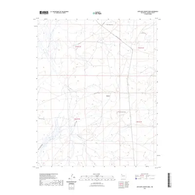
2023 Map of Antelope Lookout Mesa
USGS Topo · Published 2023About this map
Becenti serves as a central point of reference in this landscape of the San Juan Basin, where the high desert terrain is defined by prominent landforms. The namesake Antelope Lookout Mesa and Tiger Walkup Mesa dominate the topography, providing natural vantage points above the drainage of Indian Creek. This 2023 survey illustrates the modern road network essential to navigating the region, including Indian Svc Rte 7009 and Little Boy Rd. To the southwest, the terrain transitions into the steep relief of Dalton Pass Canyon. The map provides a precise look at the township and range system, marking the boundaries between T19N and T18N, which remains a critical framework for land ownership and resource management in McKinley County.
Find a feature on this map
13 named features on this map. Tap any name to fly to it.
Don’t see what you’re looking for? This feature index may not catch every label — zoom into the map to look around manually.
Map Details
Editions of this 2023 Antelope Lookout Mesa Map
This is the sole edition of this map. No revisions or reprints were ever made.
Other maps of this area

1886 · Wingate
USGS Topo · 1:250,000

1892 · Wingate
USGS Topo · 1:250,000

1954 · Gallup
USGS Topo · 1:250,000

1958 · Gallup
USGS Topo · 1:250,000

1959 · Gallup
USGS Topo · 1:250,000

1962 · Gallup
USGS Topo · 1:250,000
1963 · Crownpoint
USGS Topo · 1:24,000
1963 · Heart Rock
USGS Topo · 1:24,000
1963 · Dalton Pass
USGS Topo · 1:24,000

1967 · Gallup
USGS Topo · 1:250,000