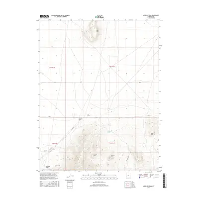
2017 Map of Antelope Peak
USGS Topo · Published 2017About this map
Antelope Peak stands as the primary landmark in this corner of Iron County, marking the transition from the high relief of the Antelope Range to the broad, flat expanse of the Escalante Desert. The landscape is defined by its drainages and isolated water sources, which were critical for early ranching and travel in this arid environment. Significant topographic features include the prominent Table Butte in the north and the sharp drop-offs of Chloride Canyon and Sand Spring Canyon to the west. Sparse but vital water points such as Antelope Springs and Rock Spring anchor the terrain. The presence of the IPP Power Line Rd and Sand Spring Rd suggests a modern utility corridor cutting through a landscape otherwise shaped by natural erosion, from the depths of Urie Hollow to the eastern heights of Three Peaks.
Find a feature on this map
18 named features on this map. Tap any name to fly to it.
Don’t see what you’re looking for? This feature index may not catch every label — zoom into the map to look around manually.
Map Details
Editions of this 2017 Antelope Peak Map
This is the sole edition of this map. No revisions or reprints were ever made.
Other maps of this area

1885 · St. George
USGS Topo · 1:250,000

1891 · St. George
USGS Topo · 1:250,000

1950 · Antelope Peak
USGS Topo · 1:24,000

1950 · Iron Mountain
USGS Topo · 1:62,500

1950 · Silver Peak
USGS Topo · 1:24,000

1950 · Desert Mound
USGS Topo · 1:24,000

1950 · Avon SE
USGS Topo · 1:24,000

1951 · Avon SE
USGS Topo · 1:24,000

1951 · Silver Peak
USGS Topo · 1:24,000
1951 · Desert Mound
USGS Topo · 1:24,000